It’s hard to imagine that only four months ago we were starting our introductory training in using the Google Earth Engine. Ever since February, we have been dreaming of how we can address our research questions with the Google Earth Engine. The Google Earth Engine allow us to expand our horizons from scaling from plots to landscapes to the entire tundra biome and to quantifying the drivers of biodiversity change around the planet. GEE gives people an easy and efficient access to many global and regional remote-sensing datasets, with the additional possibility to upload your own data. The GEE training we did in London definitely motivated us to advance our JavaScript skills and we were thrilled to travel to Dublin for the Google Earth Engine Users Summit!
We were both intimidated and excited to attend. The thing that struck us most as we walked into the Google Campus in Dublin was seeing our names on the illuminated stairs, which made us feel like we belong in this global community of remote-sensing scientists, conservationists, government researchers, small business and start up communities.


We are ecologists so we don’t always think of ourselves as programmers… how that changed, perception of quantitative skills. We always have our research questions at the forefront of our minds, but it was amazing to explore using a new tool to address. We learned new skills and pushed ourselves farther than we’ve gone before in terms of our quantitative skills.


Our favourite new skills
- Breakpoint algorithms and LandTrendr
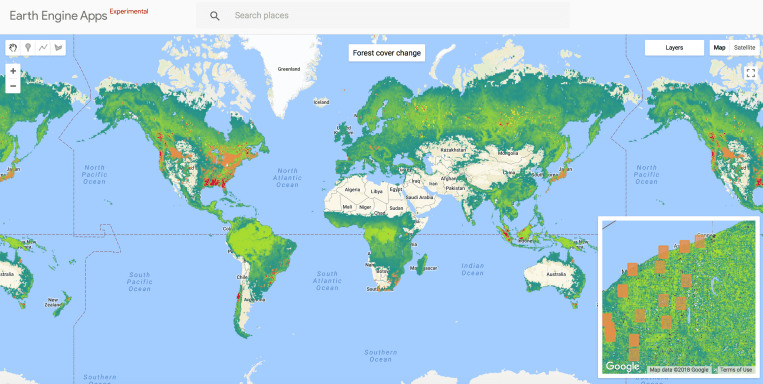
LandTrendr is set of spectral-temporal segmentation algorithms that allow us to detect changes in satellite imagery through time. Applications include monitoring changes in forest cover due to logging and fires, as well as changes in land cover types in general.
- Using the Python API to access the GEE
We think of ourselves as primarily R users, so it can be daunting to step outside of our comfort zone, but we did it!

- Machine-learning and TensorFlow
Outcome-ish: Flowers and stuff about Karol’s dissertation
• Science communication and engagement
We were especially excited about the preview of the user interface app feature for the Earth Engine! We had lots of fun building our first interactive apps and are looking forward to using web apps to share the findings of our research!
- Maps and embedding google maps into websites.

You can check out Isla’s NDVI
- Websites and search engine optimisation
We also learned about using Lighthouse to audit website performance. Lighthouse is a great free tool to see how users experience your website, and the suggestions for improvements are quite useful. We changes a few quick things on the Team Shrub website and our performance score sure went up! Though we still have lots of photos that are bound to slow down the website, we quite like sharing photos, so a few seconds of a loading delay is worth it for us!


Hackathon: Drones and the Earth Engine
How can we integrate very high resolution RGB and multispectral drone data into multi-scale analyses?
The drone hackathon was a chance to explore working with drone data in the Earth Engine and a meet up for people to discuss and test the power of the Earth Engine to answer key research questions with drone datasets.


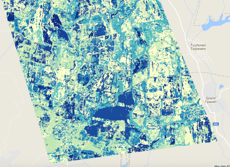
Hackathon: Detecting land abandonment using LandTrendr
Gergana participated in the LandTrendr hackathon, which linked nicely with her research of the effects of land-use intensification and land abandonment on population and biodiversity change through time. During our hackathon, we explored how we can use LandTrendr to detect the timing, magnitude and duration of land abandonment.


We are super inspired by the new skills we have and we can’t wait to get coding! Though of course it’s always great to expand your skill set, the most inspirational part for us was meeting an amazing group of people. From high school students, first year undergraduates to Rebecca Moore, the Director of the Earth Engine and Earth Outreach Programmes, we were thrilled to meet so many motivated and determined people.
Here’s to the Earth Engine and all the important research questions it can help us answer!
By Gergana and Isla
